Description
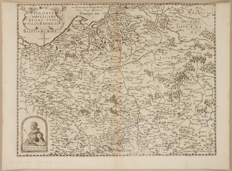
Gerard de Jode, 1593, Antverpiae, Cornelis de Jode
37.5 x 49 cm
Map reflected on 2 sheets joined by gluing with a strip of paper. Place of joining discolored brown. Upper margin heavily trimmed. On the back the text in Latin


35000,00 zł brutto
Extremely rare map of the Polish-Lithuanian Commonwealth. Second edition with a portrait of King Sigismund III Vasa. Comes from Cornelis de Jode’s atlas “Speculum Orbis Terrae…”. published by Vidua et Heredus Gerardi de Iudaeis in Antwerp, 1593.
De Jode’s maps are extremely rare because the publication of his atlas was deliberately obstructed by his cartographic rival Abraham Ortelius. The rival blocked the publication of De Jode’s “Speculum Orbis Terrae” for more than five years. Ortelius’ interference led to commercial failure few copies of the atlas were sold.
Gerard de Jode, 1593, Antverpiae, Cornelis de Jode
37.5 x 49 cm
Map reflected on 2 sheets joined by gluing with a strip of paper. Place of joining discolored brown. Upper margin heavily trimmed. On the back the text in Latin
| size | 37.5 x 49 cm |
|---|---|
| catalog | M10-38 |
![Etats De Pologne Et Lituanie Divises par Palatinats et Provinces Ecclesiastiques [...] - M. Brion](https://antykwariat-polski.pl/wp-content/uploads/2024/04/image-56-300x300.jpeg)
Reviews
There are no reviews yet.