
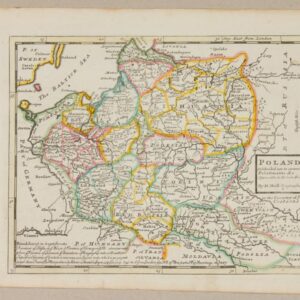
![Etats De Pologne Et Lituanie Divises par Palatinats et Provinces Ecclesiastiques [...] - M. Brion](https://antykwariat-polski.pl/wp-content/uploads/2024/04/image-56.jpeg)

Description
Louis Brion de la Tour, 1766, Paris, Sr. Devons Ingen r.
34.5 x 39.5 cm
Surface colored copperplate. Map of orbits on two fused sheets. Below rectangular frame with linear scale, number “Pl. 28”
Map surrounded by decorative border reflected from another plate. Map dimensions: 23 x 27 cm.
In the middle of the map, taped up insect marks, In the upper right margin and on the back of the sheet number “35”
Reviews
There are no reviews yet.